Proof of a secret knowledge abounds:
A few summers ago, my family and I visited
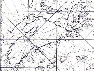
Fortress Louisburg in Cape Breton, Nova Scotia. We enjoyed our day tripping around the wonderfully well-restored historic grounds. As we were leaving, I noticed the map below in the window of the Gift Shop. I asked the people working there what the geometric marks on the map were meant to represent, but no one could say.
The map is described on the margin as appearing in de Chabert's "Voyage fait par ordre du Roi en 1750 et 1751 dans L'Amerique Septentrionale": Paris 1753.
If anyone can give me some context for the map, trip, person, and, most particularly, the geometry, I will be most appreciative:
As it happens, while the actual shape of the map is not very accurate, some of the points are very precisely placed. These points are used to define the geometry and, most surprisingly, they intersect the important points in my geometry with a chilling accuracy. There can be no doubt that the cartographer who made this map was aware of the geometry that I am tracing today.
If it might help: M. Chabert is described as "Chevalier de L'ordre militaire de St. Louis, Enseigne des Vaisseaux de S. M. Membre de L'Academie de Marine, de celle de Berlin et de L'Institut de Bologne.
This scan is a small part of the map:
I will be very grateful for any thoughts on this and any other part of these pages.
Take care,
jc
[an error occurred while processing this directive]