The Piri Reis Map & the Earth Grid
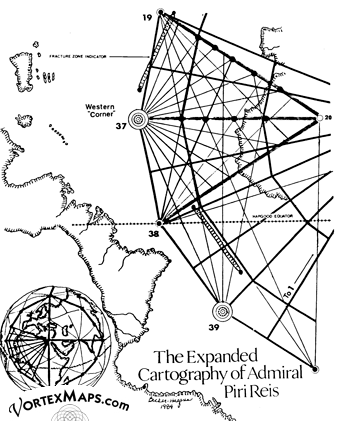
The US Navy has analyzed the Piri Reis map and determined that it is a correct circular grid projection from Cairo. The half diamond (outlined by grid points 37, 19, 20 and 38) which contains the complete construction infill of the original map shows a superficial, though perhaps indicative, resemblance to the EarthStar Globe.
An original drawing and theory by Bethe Hagens and Bil Becker.
Methodology Is Not Cartographically Valid
according to a
The Piri Reis Map of 1513
by Gregory Mcintosh on the subject of Peri Reis Map, Oronteus Finaeus Map, Mercator Map and Philippe
Bauche ancient maps of Antacrtica supposedly revealing continental outlines, landforms, continental fracture zone, etc.;
Tests of Hapgoode's, Mallery's, Strachen's, et. al., "regridding and site tables" ARE NOT ACCURATE - METHODOLOGY IS NOT
CARTOGRAPHICALLY VALID; (mathematical transformations were not made; landforms, islands, shapes were fudged to fit their hypothesis);
Capt. Mallery was only a civil engineer, not with any federal agency; USN only reviewed Hapgood's graphic results - no tests were ever made
on validity of transformations - assumptions were taken as truth. Only several persons have ever checked the validity of Hapgood's
publications since 1966.
Daniel Evan Shaw, website copyright © 2024