Geometry, Alignment & Mapping at Tulum, Mexico
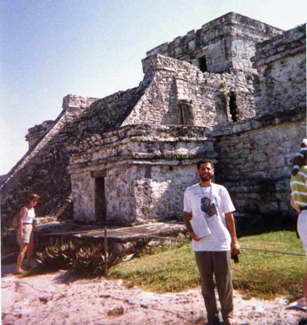
Daniel Shaw At Tulum, Mexico
Many of these causeways were built along celestial and planetary alignments, as were the pyramids themselves. Analysis of the patterns of these features may allow us to extrapolate promising locations for future exploration.
The major cities in the Yucatan could only exist because of the sacbe' ob, the straight white limestone causeways that connected them to each other, and as importantly, to their agricultural production areas. The soil in the jungle is usually not more than 10 centimeters deep, and slash and burnt fields can support only two crops of corn, so transport of crops to the cities was essential. These causeways were up to 36 meters across and level for hundreds of miles to a few centimeters. They represent more engineering effort than that of the pyramids themselves. Why such size and precision exceeding the apparent need? Can maps be obtained or produced of these sacbe' ob?
Do aerial photos of Tulum show that it is built in the pattern of the constellation "the big dipper?" The Gizeh pyramids are built in the pattern of Orion's belt, the Notre Dame cathedrals in the pattern of Virgo.
Mapping Archaeologic Sites
Southern Oregon University, Fall 1997
Professor Mairs, advising independent study
Archaeologic Sites require intensive mapping of every type and thus provide
a suitable area of study to test and demonstrate my competency and many
various disciplines, including thematic maps, urban geography, cartography,
map analysis, etc.
My goal in this independent study is to evaluate the maps of the site
which have been produced to date, and to produce something superior which
will be immediately accessible and useful to visitors to the site, a self-guided
tour map.
The site of Chichen is administered jointly by INAH (National Institute
for Archaeology and History) and Cultur (Services such a park maintenance
and tourist services). The INAH head office is in Merida, Yucatan, Mexico.
Dr. Peter Schmidt S.
Director del Proyecto Chichen Itza
Merida, Yucatan tel 91(99) 25-13-66
Centro INAH
tel 91 (99) 44-49-46/ 44-00-43 (two phone lines for the whole building)
At Chichen, Francisco Perez (Pancho) is working on his bachelor thesis; also Theobaldo Pech. Fernando Burgos and Gaspar on site.
At Chichen, there are three complexes of buildings which are open to
the public. There are at least three more building complexes which are
not developed for visitors. The outlying groups include the East Group,
the Far East Group, and the Chultun group.
I spent two days on the grounds and two days in the museum and bookstore.
The map that is provided free by INAH is only about 2-1/2 inches square.
The best available map produced seems to be the one for the Carnegie Institute
in 1929. It is not readily available, and must have been improved upon
in ways by many later researchers, but whom?
Of the guide books available, I was unable to obtain the INAH-SALVAT
guide to Chichen Itza in English. In Merida, Dante's bookstores carry the
guides, the Museum also, but it is shut on Mondays. At the museum the guide
costs only one peso, more elsewhere. It is published in a pocket format
with a silver cover.
In two days I was unable to see the entire complex. I can arrange to
go with a guided tour. But what about the pilgrim who prefers a self-guided
tour?
Self guided tour and map
What is the best way to see the most of the ruins in a short period
of time? Where are all the descriptive markers? What are the outstanding
features of each building? What parts are accessible and inaccessible?
From what era are the visible features? Are they the results of rebuilding
in ancient or modern time?
Disseminating results of this research
I am hopeful that I can arrange distribution of this information at
the Chichen ruin itself. I can post this information to my web site.
The museum at Chichen Itza:
Guide to the Exhibits in English
Text only. The museum at Chichen is relatively small, so the guide is short, but it needs more translating.
Three thousand people visit Chichen Itza each day, and many times more than that on the Equinoxes and Solstices, when the Templo de Kulkulcan (Castillo) exhibits the seven-stepped shadows on the snake-motif stairways. The Templo is a calendar memorialized in stone, by which the Mayans were able to track precisely the 26,000 year precession of the equinoxes. Specifically, fifteen days before the day halfway between equinox and solstice, we seen nine shadows. As the Equinox precesses, this date and shadow are slowly shifting.
Are Tulum, Coba, and Chichen Itza in an alignment?
I was unable to determine this with certainty. From the pyramid at
Coba, a person can look toward the coast and just make out with the naked
eye the structures at Tulum. Charred materials discovered at the sites
support the oral stories of signal fires at Tulum, and elsewhere. Tulum
is distinctive in that it is a coastal settlement. There the reef opens
up and the deeper draft boats could come safely ashore. A signal fire at
Tulum could easily be seen at Coba and vice versa, only because the tree
canopy in the flat lands reaches a maximum.
The Maya "Rosetta Stone"
What could it look like? Where would it most likely be found?
What are the priorities of archaeologic mapping?
What areas have been worked and when?
What are the 'key' features of an archaeologic map, besides past excavation,
finds, restoration, and planned digs?
What is the methodology?
What materials are available on Chichen?
Visible light? Aerial photos? Satellite?
A kind response to my line of enquiry:
You may also request the publication lists and information about the
existence of Yucatan project maps from:
PreColombian Art Research Institute
1100 Sacramento Street #1004
San Francisco, CA 94108
NOTES:
Orthographical note: The word "Mayan" is only used in reference to Maya
language. Ex: The villagers spoke Mayan.
All other uses should use "Maya". Exs: Maya archaeology, Maya villagers,
Maya Cosmogenesis.
The Maya Rosetta Stone: It's already been found. It was created by Antonio Gaspar Chi in the 16th Century at Izamal at the behest of Bishop Diego de Landa. It was used by Yuri Knorosov to initiate the breaking of the Maya code in the early '50s and extended by Linda Schele, Peter Mathews, and Floyd Lounsbury in 1972 to get full readings of extended Maya texts. A full and beautiful account is given in Michael Coe's "Breaking the Maya Code". A must read. Still available.
Alignment of Tulum & Coba? Well, since Coba was a Classic Era city and Tulum most definitely a late Post-classic city, their alignment is highly speculative, particularly since Coba made a point of connecting their allied cities with major sacbeob.
Astronomical alignment of Maya architecture? highly likely. A careful reading of David Freidel's and Linda Schele's Maya Cosmos is mandatory. Also the works of Tony Aveni on Mesoamerican archaeoastronomy.
Find more maps like this one in: American Ley Lines